![](/images/other/stat-length.png)
![Trail Walking La Garde-Freinet - La Garde Freinet - ND Miremer - Photo](https://media.geolcdn.com/t/1900/400/d65fbb3d-ce32-4ce5-ac41-4a0fcbd34098.jpg&format=pjpeg&maxdim=2)
La Garde Freinet - ND Miremer
ETMU5496
User
![Length](/images/other/stat-length.png)
![Max alt](https://static1.geolcdn.com/siteimages/upload/files/1508320355ic_sort_altitude_max_24dp.png)
![Uphill gradient](https://static1.geolcdn.com/siteimages/upload/files/1508320355ic_sort_den_pos_24dp.png)
![Km-Effort](/images/other/stat-length.png)
![Min alt](https://static1.geolcdn.com/siteimages/upload/files/1508320355ic_sort_altitude_min_24dp.png)
![Downhill gradient](https://static1.geolcdn.com/siteimages/upload/files/1508320355ic_sort_den_neg_24dp.png)
![Boucle](https://static1.geolcdn.com/siteimages/upload/files/16400158638029165_repeat_loop_refresh_sync_direction_icon.png)
![Walking](https://static1.geolcdn.com/sitytour/trail-icons/101.png)
4h14
Difficulty : Medium
![Scan this QR Code to open this trail in the SityTrail application](https://capi.geolives.com/qq0zvz2zws4bq2lad0pu/sitytour/trails/2674196/qr.png?size=200)
FREE GPS app for hiking
About
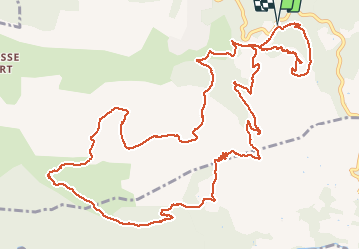
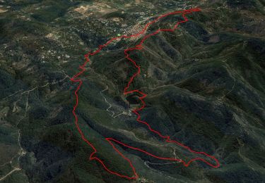
Trail Walking of 18 km to be discovered at Provence-Alpes-Côte d'Azur, Var, La Garde-Freinet. This trail is proposed by ETMU5496.
Description
point de départ : 43°18.3 N. - 6°28.51 E
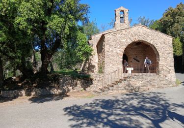
rejoindre le sommet le sommet de la colline de Miremer où se dresse La Chapelle ND de Miremer (alt 403).
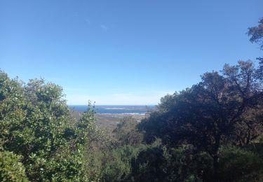
Joli point de vue sur le golfe de St Tropez
Direction ensuite le clos de Durand puis celui du Nid du Duc
Et le Val de Gilly, joli hameau à l'écart de la vie urbaine.
Direction le vallon du Camp de la Suyère et son hameau. On rejoint ensuite le hameau du Val Daubert puis les Sinières.
Au carrefour du Clos de Durand, on rejoint le pied de la colline de Miremer. Et enfin notre point de départ.
Positioning
Comments
Trails nearby
![Trail Walking La Garde-Freinet - SityTrail - Fort Freinet-la Garde-Freinet-02-06-23 - Photo](https://media.geolcdn.com/t/375/260/ce777452-e991-4230-8a3a-fe54e13fa23c.jpg&format=jpg&maxdim=2)
![Walking Walking](https://static1.geolcdn.com/sitytour/trail-icons/101.png)
Walking
![](/images/other/stat-length.png)
![](https://static1.geolcdn.com/siteimages/upload/files/16400158638029165_repeat_loop_refresh_sync_direction_icon.png)
![Trail sport La Garde-Freinet - 2024-10-30_07h08m24_Les roches blanches la croix des maures - Photo](https://media.geolcdn.com/t/375/260/ext.jpg?maxdim=2&url=https%3A%2F%2Fsecurestorage.geolives.com%2Fsitytour%2Ftrail-bg%2Fdefault.jpg)
sport
![](/images/other/stat-length.png)
![](https://static1.geolcdn.com/siteimages/upload/files/16400158638029165_repeat_loop_refresh_sync_direction_icon.png)
![Trail Walking La Garde-Freinet - La Mourre, La Garde-Freinet-22-05-24 - Photo](https://media.geolcdn.com/t/375/260/d83ec998-34f1-4f9a-9ad9-3f2fca5f6ed5.jpg&format=jpg&maxdim=2)
![Walking Walking](https://static1.geolcdn.com/sitytour/trail-icons/101.png)
Walking
![](/images/other/stat-length.png)
![](https://static1.geolcdn.com/siteimages/upload/files/16400158638029165_repeat_loop_refresh_sync_direction_icon.png)
![Trail Walking La Garde-Freinet - Garde freinet rev - Photo](https://media.geolcdn.com/t/375/260/7c0f54ba-5dae-4e90-b68b-91a753a14687.jpg&format=jpg&maxdim=2)
![Walking Walking](https://static1.geolcdn.com/sitytour/trail-icons/101.png)
Walking
![](/images/other/stat-length.png)
![](https://static1.geolcdn.com/siteimages/upload/files/16400158638029165_repeat_loop_refresh_sync_direction_icon.png)
![Trail On foot La Garde-Freinet - Fort Freinet-la Garde-Freinet-02-06-23 - Photo](https://media.geolcdn.com/t/375/260/a55d6a88-f340-481f-bdaf-db37fcbe61e6.jpg&format=jpg&maxdim=2)
![On foot On foot](https://static1.geolcdn.com/sitytour/trail-icons/100.png)
On foot
![](/images/other/stat-length.png)
![](https://static1.geolcdn.com/siteimages/upload/files/16400158638029165_repeat_loop_refresh_sync_direction_icon.png)
![Trail Walking Grimaud - Grimaud - le pont des fées - Mont Roux 11.3.23 - Photo](https://media.geolcdn.com/t/375/260/b931d4cf-3c48-45c3-9286-94f622997895.jpg&format=jpg&maxdim=2)
![Walking Walking](https://static1.geolcdn.com/sitytour/trail-icons/101.png)
Walking
![](/images/other/stat-length.png)
![](https://static1.geolcdn.com/siteimages/upload/files/16400158638029165_repeat_loop_refresh_sync_direction_icon.png)
![Trail Walking La Garde-Freinet - les roches blanches - La Garde Freinet - Photo](https://media.geolcdn.com/t/375/260/f87c2506-3a8b-4a88-ba3e-49e9b5d399bc.jpg&format=jpg&maxdim=2)
![Walking Walking](https://static1.geolcdn.com/sitytour/trail-icons/101.png)
Walking
![](/images/other/stat-length.png)
![](https://static1.geolcdn.com/siteimages/upload/files/16400158638029165_repeat_loop_refresh_sync_direction_icon.png)
![Trail Walking La Garde-Freinet - la Garde Freinet-Les Roches Blanches - Photo](https://media.geolcdn.com/t/375/260/ext.jpg?maxdim=2&url=https%3A%2F%2Fstatic1.geolcdn.com%2Fsiteimages%2Fupload%2Ffiles%2F1553511878bg_sport_marche.png)
![Walking Walking](https://static1.geolcdn.com/sitytour/trail-icons/101.png)
Walking
![](/images/other/stat-length.png)
![](https://static1.geolcdn.com/siteimages/upload/files/16400158638029165_repeat_loop_refresh_sync_direction_icon.png)
![Trail Walking Grimaud - Grimaud - Photo](https://media.geolcdn.com/t/375/260/d7d06650-601d-401f-a80f-38d8fa73f2de.jpg&format=jpg&maxdim=2)
![Walking Walking](https://static1.geolcdn.com/sitytour/trail-icons/101.png)
Walking
![](/images/other/stat-length.png)
![](https://static1.geolcdn.com/siteimages/upload/files/16400158638029165_repeat_loop_refresh_sync_direction_icon.png)